"Hometowns" is a (remote) quarter-long project by NBN Opinion in which individual writers explore the different issues that pertain to or tie them to their hometowns.
It may be 5 o’clock somewhere, but it’s Paris everywhere. If you were perchance to vigorously salt your world map with a shaker, the granules would have a high chance of finding Paris many times over – in Africa, the Middle East, South America, scattered throughout Asia and even in North Carolina. Some of these titles are mere stylization, an attempt to capitalize on the aestheticism and sexy tourist appeal associated with European cities – but many are remnants of colonialism, empire and the use of Paris as a yardstick for urban development.
Cairo’s remodeling in the 1860s, largely inspired by Eugène Haussmann’s urban planning initiative in France, gave it the title of “Paris along the Nile,” and the foreign concessions of 1840s Shanghai, especially the architecture of the French concession, led it to be called the “Paris of the Orient.” Beirut, the “Paris of the Middle East,” retained its Parisian flair when Lebanon gained independence from France, but had its architecture ravaged by civil war.
Story of cities #12: Haussmann rips up Paris – and divides France to this day https://t.co/oG30zHdNlz
— The Guardian (@guardian) March 31, 2016
In 1639, a fishing village called Madrasapatnam in South India was purchased by the East India Trading Company — a British corporation that both National Geographic and the larger body of history itself label as “the trading firm [that] took control of an entire subcontinent.” The village was called Madras until 1998, in which time the British developed it as a port city and a center for trade. This city, whose name was changed in 1998 to Chennai, is a 2 hour drive from former French colony Pondicherry, which is sometimes referred to as “the Paris of India.” As a Chennai resident, it is a matter of some small annoyance that we got the quote unquote “unsexier” end of the stick, nomenclature-wise – Chennai is apparently called the “Detroit of India” for its large automobile industry.
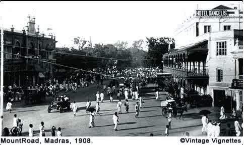
A matter of somewhat larger annoyance is the idea that Chennai should be defined by its industrial activity alone. As a city developed in part by a colonial power, it is spatially near impossible to define at all – traditional dwellings and livelihoods coexist in a volatile fashion with commerce and modernity. Many of Chennai’s older commercial institutions – banks, insurance agencies, important markets and bazaars – occupy urban spaces that are defined by colonial planning. Many of the city’s arterial roads were constructed by the British, and although the official names have changed, they remain synonymous with affluence and commercialization. Poonamallee High Road, the longest road in Chennai, is bordered by multiple civic institutions, including the Ripon Building, the city’s town hall, and the central train station. Anna Salai (or Mount Road) was the traders center of Madras, and is now lined by banks, gentlemen’s clubs of the P.G Wodehouse variety, government buildings, and colonial landmarks. The institutions along these roads are especially interesting in that they seem to represent capital C Centralization – of finance, of trade, of governance, of influence.
Centralization is an odd concept in what was, after all, a fishing village – one whose governance of land and ecology has historically been decentralized. What made Madras valuable to the British to be developed as a port city – the proximity to the ocean – is also what makes a lot of its land area ecologically sensitive. A lot of Chennai is wetland, both natural and man-made from precolonial times, which supports communal livelihoods around water like fishing and salt farming. A particularly noteworthy part of the South Indian water topography are eris - systems of interconnected bodies of water (open tanks or lakes) used for irrigation, built and/or managed in precolonial times by communities. The design and engineering of eris, as well as the use of environmental conditions in their maintenance, were incredibly ahead of their time.

But in the years of urban expansion in the late 1900s, eris were among the first to go. Most of them are now at best disused and at worst no longer water bodies at all. Some of them have fully or partially been filled in with cement and buildings to make bustling residential districts, or to accommodate rapid growth in the IT sector. The government of Tamil Nadu continues to build into wetland areas to accommodate industrial growth, a problem that has been associated with rapidly increasing water insecurity in the state. With a coast that borders the high energy Bay of Bengal, an intense two month rainy season, and destruction of floodplains, wetlands, and eris where that water can safely be stored, Chennai has become an epicenter of water related natural disaster — floods, cyclones, droughts that are visible from space.

The reasoning behind this allows us to come full circle, on development, colonialism, and centralization. Eris were taken from the capable jurisdiction of local communities by the British, and centralized under the Public Works Department. This centralization appears to be part of the European template for development, a program that created gaps in the spatial organization of the city – gaps between traditional and Western, local and imported, ecological and industrial. Decades after independence, the state government pursued industrialization at the expense of the environment by designating ecologically sacred wetland as economic zones for the building of ports and power plants - exposing and widening these gaps once again. They sacrificed local traditional livelihoods, and safe access to water for the whole state, to clear space for multinational corporations and the European spectre of development. Flooding and disaster in Chennai show us how these gaps have the potential for catastrophe – when a Western template is applied to a place with vastly different ecology, topography and demographics, it sets an impossible precedent for what development should look like.
History remembers Cairo, the Paris on the Nile, for its differences and imperfections when compared to its European counterpart. The Western concessions of Shanghai, the Paris of the Orient, received a great deal of credit for the city’s emergence as a global force. Modernization theory holds the development of countries in the Global South to the standard of Europe. But Chennai shows us that this “development” is an ideology, a very imperfect product that attempts to be transferable when it is not. The danger of using Paris and Europe as a yardstick is that it does not make room for variety – of people or of land.
Editor's Note: The views presented in this story belong to the writer and are not necessarily reflective of North by Northwestern as a whole.